

Helene is developing a large clear eye as it approaches the coast, and has strengthened into a serious Category 3 hurricane. It may yet reach Category 4 before landfall. With all the hype and exaggeration that has started to surround these events, don’t mistake the fact that in the landfall area this is a very dangerous storm. If you are in the warned areas you need to take immediate action. NHC’s official guidance is in the Key Messages regarding Hurricane Helene (en Español: Mensajes Claves).
Those on the coast should already be gone; this storm will almost certainly generate storm surges over 20 feet. Inland, if you are in the red area in this map, it’s going to be a rough night.
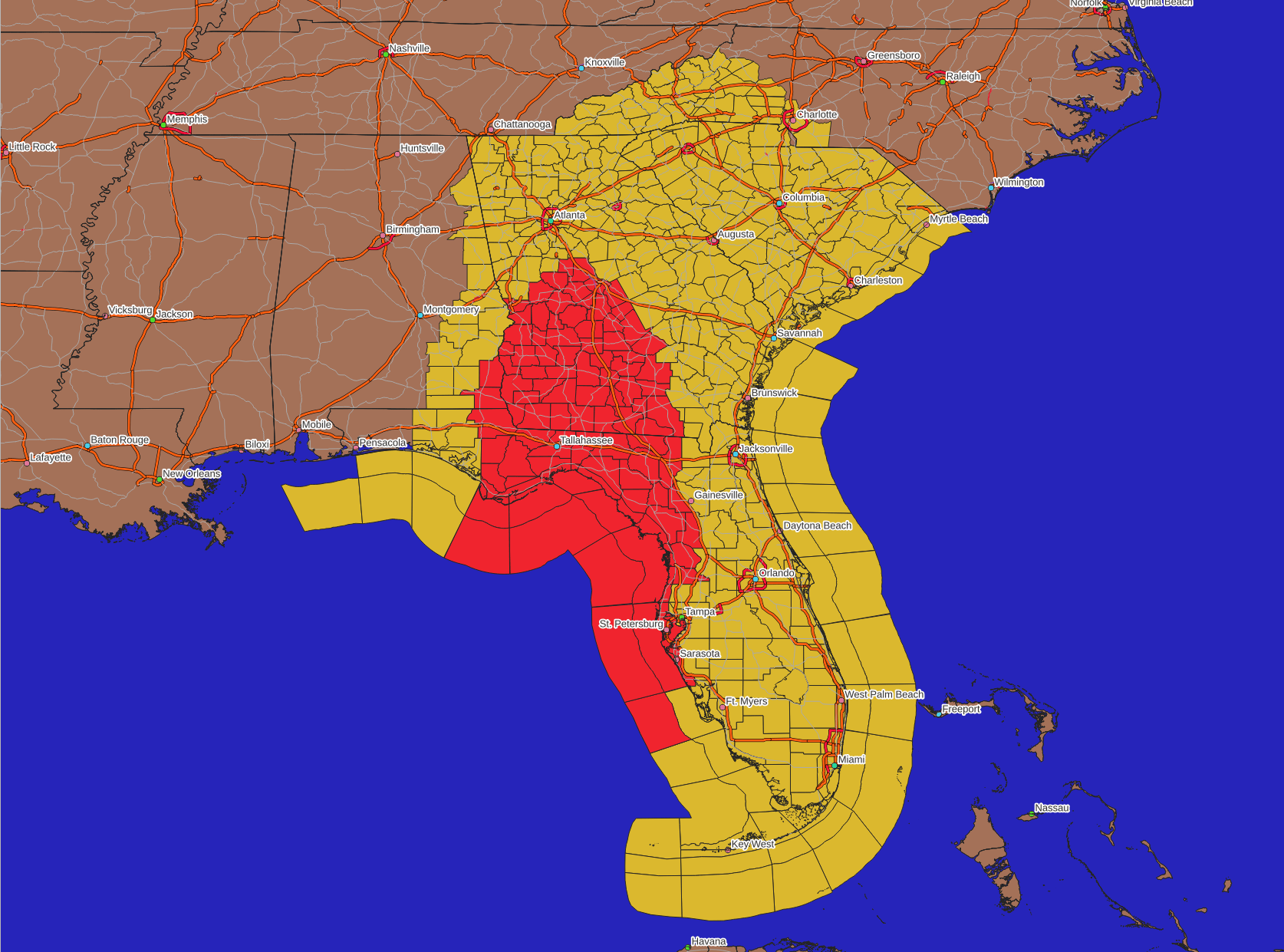
Those in mobile homes in that area for sure, and probably in the adjacent counties, should probably seek more secure shelter. This is a fast moving storm and you’re running out of time.
For the rest, there will (and in Florida and parts of Georgia already are) gusty winds, rain squalls, and the tornado or two. Scary, but as I’ve said repeatedly shouldn’t be particularly dangerous with some common sense. The gusty winds will cause power outages, limbs and the occasional tree down, etc. I’ve described the likely impacts in the previous posts today such as at this link. Nothing substantive has changed.
Here are the latest satellite loops in IR and Visual bands …


And here is the current radar, showing the storm just offshore from Tampa/St. Petersburg:

Next up is the forecast damage swath based on the 5pm NHC forecast. Again, it really hasn’t changed a lot, as explained in a previous post much of the so-called track shifts were an illusion, but there was a minor shift to the east.

With such a big storm it’s not making that much of a difference. One thing I did note is that in NHC’s latest discussion is that they are using a larger gust factor than normal for this storm. Typically sustained winds of, say, 35 mph would produce gusts to 45 or 50, but they are padding that to 50 mph. This all plays in to something that I discussed in another post (I’m saying that a lot today), that there are lots of different ways of measuring and reporting wind. Since I’m mainly concerned with dynamic pressure that causes damage, my numbers haven’t jumped around too much
Speaking of damage, the larger storm and somewhat higher sustained winds inland means the economic impacts will be higher. The NHC value jumped *way* up as they are now keeping the inland winds far higher into the target rich Atlanta area (but the HFSx models, which had be so high, dropped a lot). This had a bad impact both there and the agriculturally important and valuable central and south Georgia region, where harvest season is just beginning for some important crops. Here’s the latest Tukey plot:

The best bet is this will come in at $20 to $25 Billion in impacts unless the storm just crashes in intensity at landfall. That’s possible, but hope isn’t a plan so don’t count on it. If the NHC estimates on inland wind and the gust factors are correct, then $30 Billion isn’t out of the question.
On thing that wasn’t forecast is that the Savannah area had some unexpected heavy rain this morning, we got 3.75″ at the Enki offices (almost as much as was expected from the whole storm tonight!). That same band spawned a tornado in Beaufort County that caused quite a scare during the morning rush hour.
Although there is a dry slot to the right of the storm (visible in the radar image above), another couple of inches of rain are possible in Coastal GA and SC overnight. That said, as noted before we shouldn’t get the kind of really bad flooding we got with Debby. Be sure to keep your weather radio on, we will likely get more tornado warnings – especially the inland counties. Again, the forecast impacts detailed this morning for the Frogmore Metroplex (Savannah, Beaufort, and HHI) are holding up other than the extra rain.
Unless something dramatic comes up, next post will be early in the morning when the storm is hopefully mostly past the Savannah area. Take care tonight
Thanks so much for all who have contributed! If you like this kind of commentary you can subscribe to the emails (and/or donate to keep it going) at this link. You can also follow us on X/Twitter (@EnkiResearch) or even Facebook if that’s your preferred social media miasma.
THANKS FOR YOUR CONTINUED UPDATES
I have shared your site with so many of our family and friends in this area.
What do you expect for areas 60+ miles north of Atlanta, like Jasper and Elijay? The local news is making it sound like the end of the world. I trust your assessment 100x more than the talking heads on TV.
I love your comments/descriptions….especially your references to Frogmore!
Frogmore is the Capitol of The South!