

Despite beginning to interact with the wall of wind shear located right along the Gulf Coast, Isaias continued to intensify overnight. Here are links to NHC’s Key messages regarding Hurricane Isaias (en Español: Mensajes Claves), and this is the forecast damage swath as of 5am this morning (Friday) using that forecast and my TAOS(tm)/TC model:
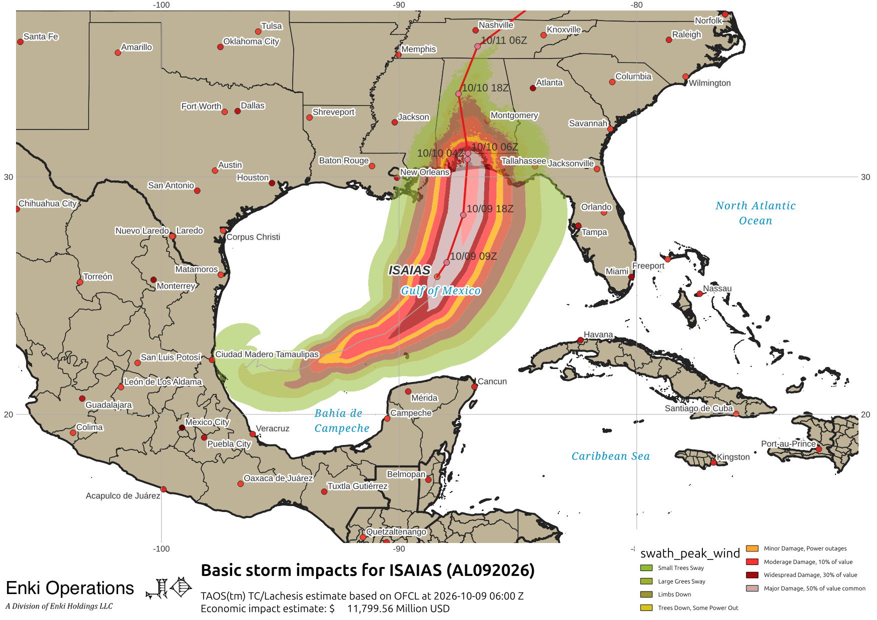
The first thing to notice is that NHC has upped the landfall intensity to 105kts/120mph, a solid Category Three storm. While the hope is still that the shear will knock the storm down at least a category before landfall, the better organization and righter eyewall that developed overnight may allow a stronger storm to reach land. As noted yesterday, hope is not a plan, so if in the damage zone things will get rapidly worse as today goes on so prepare for high winds, coastal flooding, and heavy rain …

On this track the models are forecasting upwards of $15 Billion in economic impacts – double from yesterday, due to the higher landfall intensity, location shifts, and inland penetration of tropical storm force winds. Notice the flood and wind warnings extend far inland – so the entire southeast could feel the effects of this storm to some extent:
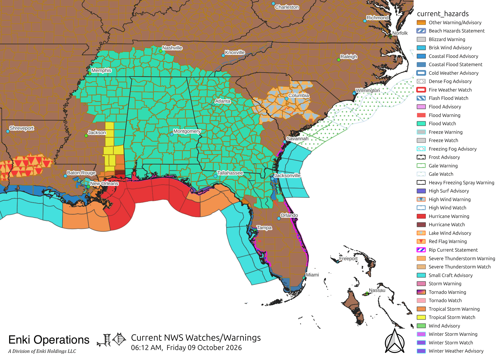
As you can see, the entire state of Alabama is going to experience high winds and flood risk. The tornado risk from this storm is elevated both because of the geometry and the interaction with the frontal boundary. Heavy rain is a definite risk from this system. Here’s the forecast three day rain swath:
For Coastal Georgia and the South Carolina Lowcountry (the beloved Frogmore Metroplex), winds will pick up this afternoon with rain starting overnight. Tomorrow promises to be a blustery, rainy day. High waves and gale force winds are expected along the coast – this isn’t directly associated with Isaias, but the frontal system that stalled over us this week is being “supercharged” by interactions with the storm and it’s all blending together. Bottom line is as long as you don’t do any Lt. Dan re-enactments you should be ok.
There is some slight risk of weak tornados and water spouts, so keep your weather radio on. Wednesday’s siren test was delayed until today, hopefully they have the sense to kick the test to next week.
As for rain, the heaviest bands should hug the coast. There is some uncertainty here – for example, downtown Savannah looks to get 2-3 inches, but if these track even a little more inland that amount could easily double! Frogmore itself and the Islands looks to be in the 4″ range, but again could easily spike to 8″. So be aware of that. There is some risk for shallow coastal flooding at high tide Saturday. Here is the relevant slide from this morning’s briefing by Charleston:

Western Georgia, expecially west of Valdosta and south of Columbus, should prepare for tropical storm conditions and heavy rain. The tornado risk is significantly higher out there. Atlanta will be miserable as always, but it will see high winds and heavy rain. Air traffic will be disrupted all across the southeast this weekend – talk to your airline no matter where you are traveling to or from, schedules are likely to be a mess.
Georgia/Alabama game? Still looks like they are going ahead with it, not something I would have advised. As it is said, “Bold move, Cotton … let’s see how it works out.” If you plan on going be careful, travel across the region will be rough tomorrow.
For those interested in a few more technical details, here’s some notes. As I said yesterday, this situation is pretty well behaved for the most part aside from the interaction of Isaias and the shear/frontal zone, so people babbling about his or that model or wobbles in the track are mostly trying to fill time, keep you enganged, and sound like they know what they are talking about. For the average person the NHC forecast is where you need to put your attention and the stuff below is just the science/meteorology.
Structurally Isaias is a well developed system. The sun isn’t up yet, but here is the IR loop, you can see the eye structure and banding:

The surface analysis shows a little deformation in the outer inflow region but this looks like a pretty solid, mature system:

Looking higher in the atmo, comparing the 850mb (5000 ft) and 300mb (30000) winds, you can see the intense shear zone to the north and the interactions are well underway, but as of yet, as seen on IR, it’s not started weakening the storm:

The key question at this point is when all that shear is going to rip the storm apart. GFS shows it hanging in there for quite a while, with winds extending all across the southeast:
For that we will know for sure Sunday, after it’s mostly already happened 😛 …
If you appreciate the blog, the best way to get it is to subscribe to the free emails. You can subscribe and also donate to keep it going at this link.
THANK YOU for the surge in donations over the last week!!!
While email subscriptions (which again are free, but do depend on donations to keep things going) are the best way to get these screeds, you can also follow us on Musk’s Madness X/Twitter (@EnkiResearch), Telegram, or BlueSky.
The internet is rapidly becoming a dystopia, far from the vision of an open, free exchange of information that it began with. In administrative news, Meta/Facebook has made it official that they are only allowing TWO outside links per month for organizations that don’t pay them for the privilege. During a real-time hurricane or ice storm event impacting the US, I often post two or three times a DAY or more. It would cost about $500/month to continue to post blog links there as I have in the past, about 1/3 of the current level of donations. For Isaias I’m still posting, (if you’re here you probably know you can still get to the blog through the Profile, if not the actual posts, but I’m sure that will be blocked eventually).
This really offends me. Social media providers exist because people post their content on them – these companies exist because of the work of others. Now they want to charge content providers for the privilege (and still profit from ads and scraping content to feed their AI projects). They are trying to have it both ways – profit from your work, *and* charge you for it, where it the past is was a shared system. Obscene.
I think it’s time to change the name of the Gulf of Mexico to the gulf of frogmore.
Meritorious idea, but the Gulf seems a bit small for the magnificence that is Frogmore. The body of water to the east cries out for a more noble name – perhaps rename the Atlantic to the Frogmore Sea?