

As expected NHC started advisories on the system in the Gulf of Tabasco (that’s a real thing by the way, part of the area more broadly called the Bay of Campeche, it’s the southern part of the Gulf of America/Mexico if you’re trying to avoid politics). It quickly gained tropical storm status, here are NHC’s current Key messages regarding Tropical Storm Isaias (en Español: Mensajes Claves).
The forecast is for a dramatically stronger storm than the initial forecasts last night, now predicted to be a borderline Category 2/3 storm at landfall. Here is the forecast damage swath based on the NHC forecast, using my TAOS(tm)/TC economic impact model:
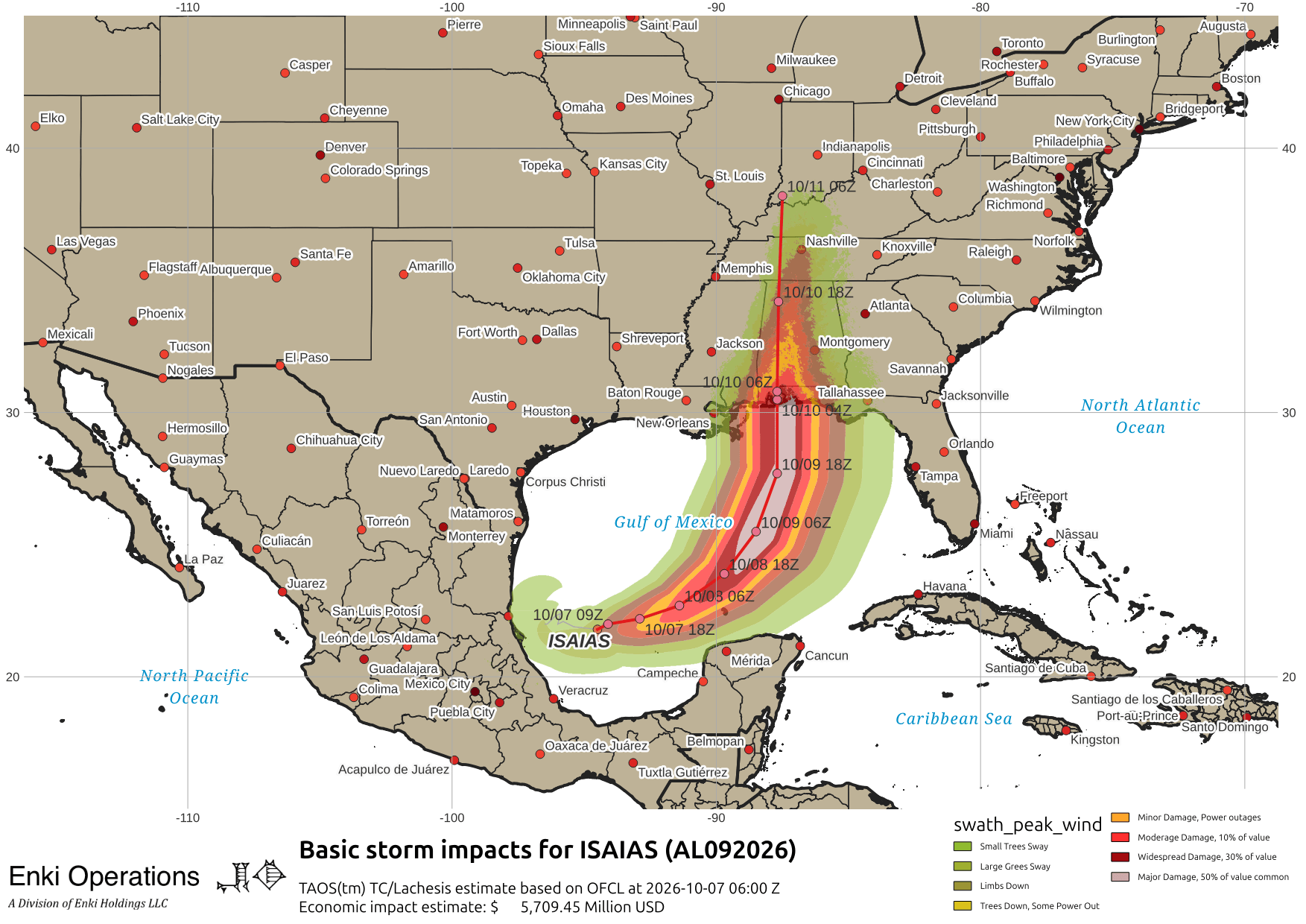
The tracking is still centered on the Alabama/Mississippi border. NHC has shaded the track towards the east a bit, but anyone between NOLA and Talahassee definitely needs to be paying attention since watches are likely to go up later today and preparations will be starting. Here’s the track map as of this morning. You can ignore the two orange lines fanning out to the far right (east), those are trajectory models and unlikely in this scenario. The green line is climatology – that’s where storms go on average at this time of year, and is just for reference.

So “where” is fairly well pinned down (again, the area from New Orleans to Tallahassee). “When” is Friday night and Saturday morning. It’s the “How Bad” that is still in question. Despite the still broad circulation pattern, NHC is worried that Isaias could rapidly intensify. Here’s the intensity guidance:

The regional models (blue/green in this graphic) are exploding the storm into a major hurricane. The global models and statistical/dynamical models are less enthusiastic. The Rapid Intensification analysis by the Regional and Mesoscale Meteorology Branch (RAMMB) at Colorado State shows there is a good chance of intensification in the short term – initial conditions are favorable, and there is a lot of energy available. However, just to the north of the storm, along the coastline, is an area of very high wind shear associated with a cold front moving through the southeast:

So even if the storm intensifies rapidly offshore, as it gets closer it should hit a “wall” and rapidly collapse. This can be seen in the intensity graph above, and this wind shear analysis shows the wall of shear to the north. So what does all that mean?
Following the NHC guidance, Isaias should make landfall as a Category 2 storm with the eyewall passing over or near the Mobile Alabama area. Mobile Bay is especially susceptible to storm surge. Damage there, the beaches like Gulf Shores, and the area to the west around Pascagoula Mississippi could be extensive. The storm is likely to be asymmetrical and collapsing by the time of landfall, so impacts to the east (Pensacola, Eglin AFB) are likely to take a hit as well. This would cause upwards of $6 to $10 Billion in impacts.
Inland is a bit more difficult to forecast. The storm should collapse rapidly, likely more rapidly than shown on the NHC based forecast, but at the same time it will be pumping moisture and a wind gradient into the interior. Therefore, it will be a blustery rainy day Saturday across most of Alabama. Here’s the fancy animation thing, notice the collapse on hitting the shore:
Apparently there is some form of ritual combat between an elephant and a dog taking place at a site with the unlikely name of “Tuscaloosa.” To make it an even more surreal event that only AI slop could dream up, the President is supposed to attend (apparently the Gulf didn’t like being renamed 😛 … ). That event is right in the middle of the impact swath, I wouldn’t be surprised if it gets postponed. Winds in the 50mph range, thunderstorms, and possible tornadoes aren’t a great mix for that sort of thing.
Will update as things change, probably this afternoon when the watches go up and we have a better handle on intensification trends.
If you appreciate the blog, the best way to get it is to subscribe to the emails. You can subscribe and also donate to keep it going at this link.
THANK YOU for the surge in donations over the last week!!!
While email subscriptions (which are free) are the best way to get these screeds, you can also follow us on Musk’s Madness X/Twitter (@EnkiResearch), Telegram, or BlueSky.
The internet is rapidly becoming a dystopia, far from the vision of an open, free exchange of information that it began with. In administrative news, Meta/Facebook has made it official that they are only allowing TWO outside links per month for organizations that don’t pay them for the privilege. During a real-time hurricane or ice storm event impacting the US, I often post two or three times a DAY or more. It would cost about $500/month to continue to post blog links there as I have in the past, about 1/3 of the current level of donations. Therefore, I am suspending regular posting on Meta properties for now. If enough people donate and specifically request it, I’ll resume regular Facebook posts with links, but otherwise I can’t see duplicating posts there just to feed Zuck’s gulag.
I am disgusted with FB. All the ads and garbage there, but they want to charge $500.00 a month for useful, unbiased info. We really are doomed!
Thank you for continuing your entertaining email.
Thank you.👍