

Although we are still outside the window for reliable snow forecasts, the indications are increasing that coastal GA/SC will get something next week. Here is what the NWS office in Charleston (responsible for the Frogmore Metroplex) has to say this morning:
Transitioning to Tuesday and beyond, the forecast becomes
increasingly tricky and potentially impactful. Much of the forecast
depends on how far south and offshore the low pressure tracks off
the Southeast U.S. coastline. With the 00Z GFS/ECMWF/CMC
deterministic model runs suggest snow will be the main p-type with
this system. PoPs were increased a bit for Tuesday and Wednesday
morning to 40-60%. Most of the models are in agreement that most of
the precipitation should end by Wednesday afternoon. However, some
uncertainty still remains regarding the amount of snowfall we might
receive. The cold temperatures is an aspect that we can speak about
with high confidence, and it will be very cold. In fact, there are
signals that some locations could see wind chills drop below 10
degrees on Tuesday night and Wednesday night which is dipping into
Extreme Cold Warning territory (10 degrees or colder). We could even
break the record low temperatures at KCHS/KCXM/KSAV on Thursday.
Similar language to yesterday, but leaning more towards snow, and a lot more detail on the temperatures, which look to be near record lows. Right now it looks like it could start snowing/freezing rain Tuesday morning, change over to rain in the afternoon, back to snow Tuesday night. Here’s what the hour-by-hour forecast plot looks like for mid town Savannah – notice how it says “snow amount forecast data is unavailable” – that’s because it just isn’t reliable, so ignore all the snow totals at this point, they just aren’t reliable.Also notice the temperature profile, which is more reliable, has a temperature in the 20’s and wind chill of 17 degrees …
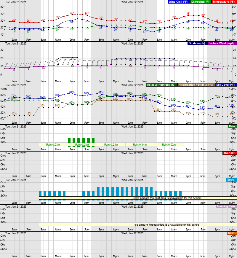
Here’s the obligatory ten day animation:

As noted yesterday, you should always be prepared for at least a few days of disruption, be it hurricane, ice storm, or something else. As usual, a good place to start is the DHS/FEMA web site, which has checklists for that sort of thing. Again, this applies year-round, since lots of things ranging from natural disasters to human error to malicious intent like terrorism or riots can result in several days of disruption to every day life. Being able to fend for yourself for a week isn’t paranoid prepping, it’s just common sense. If you can be ready for two weeks, that’s great, but in most cases at least some help gets in to an area within 5-6 days.
Bottom line: snow seems more likely, worth preparing for, but still some uncertainty. In this case, any significant snow (much less ice) will shut the region down. I remember being home on leave in Savannah around Christmas one year when it snowed, and walking over to Abercorn to watch the ice ballet of cars slowly skidding around and playing bumper cars. Fortunately nobody was hurt – but nobody was going anywhere, and I bet the insurance companies took a bit hit on car repairs that day. So make sure you are prepared to stay home a couple of days (“shelter in place” is the scary phrase, “hunker down” if you are from the South), but don’t be like this guy and Hamsterkauf (“hamster purchase” – what Germans call panic buying, especially of toilet paper):

Finally, a brief update on the GPS situation in Savannah: the Army has an exercise scheduled at Hunter Army Airfield (HAAF) for next Tuesday/Wednesday where they will be doing GPS interference testing. If they go ahead with it, it is mostly an issue for aviation. There isn’t any need to worry about it, there are ground based backup systems (the VOR and ILS based navigation systems), and pilots use and practice with these all the time. On the ground, in the immediate vicinity of HAAF you may get glitches where your GPS loses lock or gives bad locations. Nothing to panic over but be aware if it, and besides, you should always be vigilant for GPS and mapping errors anyway – don’t be like these people who got in to trouble by blindly following the voice …
Re: winter driving in Savannah… Someone dumps a cooler in a parking lot and you’re gonna have to get out there and start directing traffic.
Hope Snow Jam ’25 is a safe one.
Thank you for your updates! We are fortunate to have you and your trustworthy reporting!
Waiting for the “I’m from the north. I know how to drive in snow”. Well, Minnesota gets vast cargo shipments of the stuff all winter. They take it seriously, despite awesome snow equipment, and the stay the $&@! off it.
I’m reserving seats at the Truman/Abercorn crashersection.
Absolutely – not to mention they salt/sand the roads as well as, like you said, have the snow clearing equipment and the sense to stay home until it’s cleared (or Darwin has already taken care of those who don’t 😛 ).
I remember the 1989 Christmas snow. I was young and working at the hospital. ( Also just remember the 1968 snow when I was pre-k age and a couple of episodes in the 1970s. )
Thanks for the insight and the warning regarding the snow total predictions. They are in the “unbelievable” category based on our history! Guess we should just say there there will be some snow.
Wonderful and very trustworthy. Please keep it up. You are very reliable!
With the possibility of a ‘SMALL’ winter storm happening in the Savannah area, I hope the residents do not panic and be mindful of their and their families safety. Albeit no matter how extreme or slightly exaggerated the forecast is, there will be people “wanting” to venture out on the roads. It just means that being human, is being human…and human nature is to be curious even if it is stupid. Stay home and learn something by reading a book or talking with your loved ones. Stay safe Savannah!!