

TLDR: Debby has slowed and is presently just southwest of Savannah, and is expected to drift slowly offshore during the day. Lots of rain, flooding in places, but totals aren’t (yet) as epic for Georgia and may not be, as it seems the highest flow of moisture will be in the Carolinas today as the storm lingers, then moves north.
Debby has slowed and decayed quite a bit overnight, with the west and south side almost devoid of precipitation as seen on the 5am radar …

The reason, as noted yesterday, is that dry air has been pulled in to that part of the storm. That is vividly seen in this 6.9um GOES EAST image. The 6.9um band is known as the middle troposphere water vapor band – a fancy way of saying it lets of look at the amount of water in the vital (for a hurricane) middle part of the atmosphere:

As can also be seen, there is a lot of moisture being pumped into South Carolina. Right now it is Charleston that is being pounded. This graphic shows the rain rate at 6:00AM …

Those in the Lowcountry (Hilton Head, Beaufort) they will continue to be on the fringes of this with the core of the heavy rain continuing to hit in South Carolina, mostly from Charleston and increasingly to the NC border and beyond.
Over the last 24 hours South Carolina, between Frogmore (Beaufort, Sun City, and Hilton Head are suburbs 🙂 ) and Charleston have seen the brunt of the rain, and that is likely to continue. Here in midtown Savannah, the Enki rain gauge is showing a storm total rainfall of 180mm (7.06 inches for those of you living in the dark ages). That seems typical, a few isolated spots are pushing 10″ but in the Savannah area the radar shows 6 to 8 inches on average. Beaufort is a bit higher, 10″ to 12″.

The latest NHC forecast – Key Messages regarding Tropical Storm Debby (en Español: Mensajes Claves) – has Debby spending most of the day drifting due east. Here is the 5am forecast impact swath map:

NHC is now forecasting Debby to drift east today, then move inland over Charleston – but as those in Savannah already are experiencing, the center of this storm isn’t where the problem is, it is the north and northeast sectors. Tornadoes and heavy rain will be the order of next two days in South Carolina and southern North Carolina, and tropical storm warnings have been extended over night:
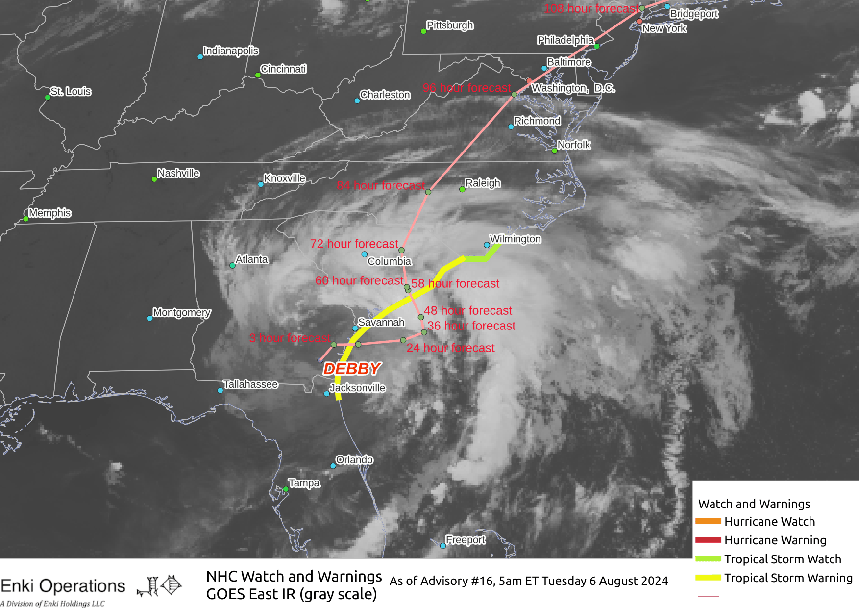
To sum up the forecast, while the winds and storm surge caused some damage in Florida, the biggest potential problem with Debby remains rain. Georgia will see squally weather today (beware gusts bringing down water-logged limbs as the storm moves offshore) with a few isolated downpours, but the risk of tornadoes and super-heavy rain is decreasing with every hour. Areas that flooded yesterday evening should be able to drain off although there is still the potential for the usual places to flood again in one of the passing heavy showers. The Beaufort area is more at risk to continue to get heavier rain, but the worst should be in the area from Kiawah to the NC border today.
Central and north SC and southern SC look to be seriously pounded with rain over the next 2-3 days, and widespread flooding there seems unavoidable. Longer term Debby (if it remains an organized storm) is forecast to be picked up and ejected northeast toward Canada by day five. If it does stay organized, and if it goes offshore, it could bring tropical storm like conditions to Vinland (Nova Scotia). But that’s a ways off.
If you like this kind of commentary you can subscribe to the emails (and/or donate to keep it going) at this link. You can also follow us on X/Twitter (@EnkiResearch) or Facebook if that’s your preferred social media sewer.
I found your email source just two days ago and immediately subscribed! Your explanations of what we’re going through with Debby are easy to understand, very informative without being too technical, and best of all, no hype! Thank you for providing this service!
This has been fantastic information thank you for what you do! I wanted to say that I live on James Island in CHS (since Dec of 23’ so very new) and we’ve had higher water levels from a heavy rain shower. I’m not sure why but this really hasn’t been bad at all…. So far. The heavy rain picks up occasionally but seems to die down quickly giving time for the water levels to recede without building up. Fingers crossed this story holds.
Well, you won’t find a more comprehensive analysis than that! Thanks for all of your labor and knowledge. We lost power where I am at 12:30am, but it seems that it is not universal on our street, so hoping that we get it back today if the rain allows. Luckily, my husband is running the generator, so we could inject coffee into ourselves. My son isn’t thrilled, but he can watch videos due to the generator. That is a win, Savannah was fortunate, overall, so I will not whine! I definitely feel for South Carolina.
Thanks again! ( we had a lackluster introduction to the metric system when I was at school, so I fear I still think in inches and yards!)
Excellent analysis and much appreciated. Thank you!