

TL;DR: A dry cold front is moving through Coastal Georgia and the South Carolina Low Country (better known as the Frogmore Metroplex) today. Emphasis on the word “dry,” drought conditions have returned. One lone tropical storm in the mid-Pacific as northern hemisphere hurricane season winds down.
First, the tropics are winding down across the Northern Hemisphere, just the disorganized and fading Tropical Storm Pena well southwest of Hawai’i …

In the US, a mass of cold air behind a dry cold front is pushing through the south today. Unfortunately not seeing a lot of rain in it. Here’s the radar as of just before 7am …

Here is the GOES East “Air Mass” composite image (more on the air mass product at this link). You can see the colder air mass to the north in shades of dark blue/purple (and some white clouds over the Ohio river valley), which will be pushing south into the warmer greenish mass during the day:

Putting things into motion, here is the GFS forecast showing the air moving south …
Inland areas will likely get frost/freeze advisories for the weekend, we’ll get those tomorrow. It is extremely unlikely freezing temperatures will reach the coast. The usual “coastal/inland” boundary applies: I-95 in Georgia, US-17 in South Carolina.
The big problem, as noted, is the fact the front isn’t bringing us any rain. Our soils are drying out again, and drought conditions are returning across the coastal GA/SC region. Here’s the soil moisture sensor here in Midtown Savannah …
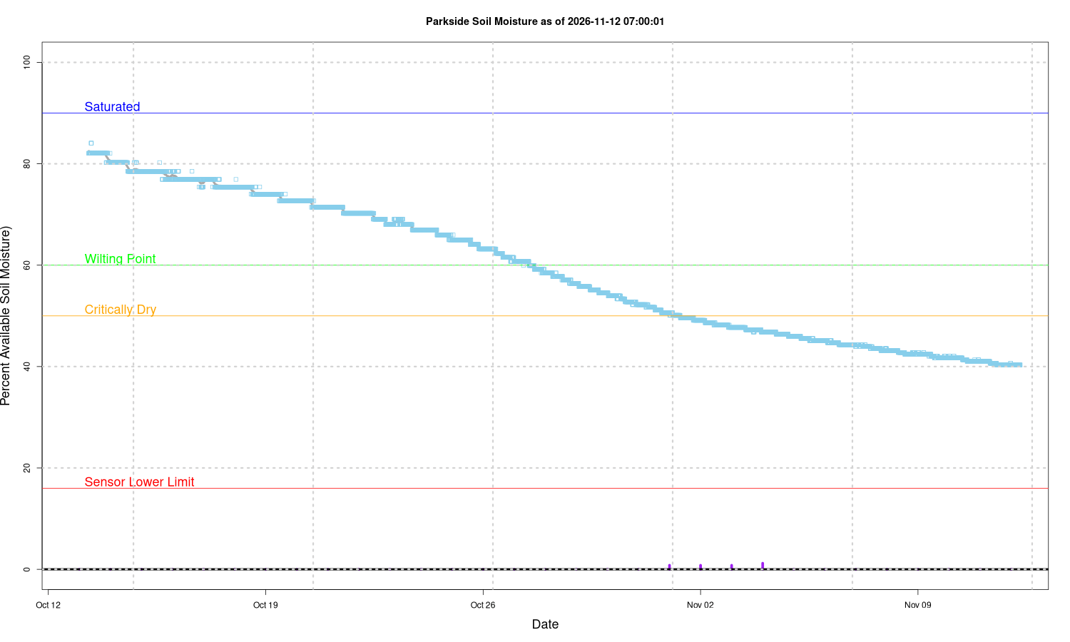
It’s now been over a month since we’ve had any serious rain. Of course this is less of a problem now the growing season is over, however, it means the deep soil moisture is starting to deplete again after (almost) recovering in the late summer. Hopefully we will be getting rain this winter to restore it before spring. The other thing soil moisture does is moderate the impacts of freezing temperatures. Although that isn’t a factor in this cold snap, it may be later this winter. It takes energy to convert water into ice during the freezing process, so that has a protection effect on plants. So a cold snap during a drought can be harder on them than when moist
We do expect more rain as we enter an “El Nino” winter – hopefully not too much of a good thing! As always, will be watching …
If you appreciate the blog, the best way to get it is to subscribe to the emails. You can subscribe and also donate to keep it going at this link.
While email subscriptions (which are free) are the best way to get these posts, you can also follow us on Musk’s Madness X/Twitter (@EnkiResearch), Telegram, or BlueSky.