

The winter storm forecast to Elsa the deep south is now trekking across the region. As of 5:30am, snow is in a swath from southern Louisiana to Northeast Georgia …

and will continue to progress rapidly eastward. As the cold arctic air interacts with the moisture streaming up from the Gulf of Mexico America 😛 , depending on where you are you will see snow, sleet, freezing rain, rain, or all three. Especially for the areas that get freezing rain, this will be a mess. If you’ve got some money in your pocket, even if you don’t know where you got it, spend it today because travel the next couple of days will potentially be hazardous.
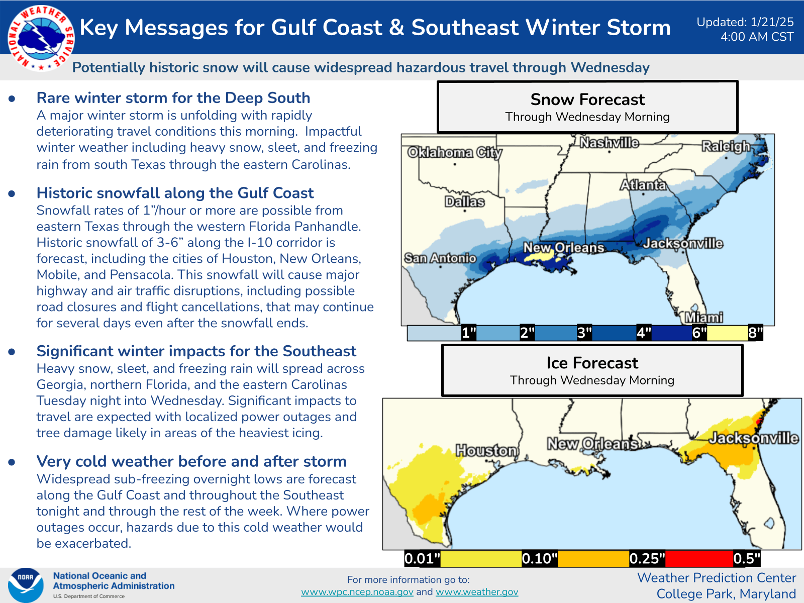
Here is what WPC has to say in their latest ‘Key Messages‘:
Concentrating on the Georgia/South Carolina coasts, better known as the Greater Frogmore Metroplex, today will be cloudy with temperatures not changing much, hovering in the mid 30’s. The winter storm warning goes in to effect for that area at 5pm, because after 6pm there will certainly be something In The Air Tonight. Hold on. Just what that something will be is complicated. Looking at the precipitation type estimates for Daffin Park (in Savannah, Georgia, located about 30 miles south of Frogmore), here is what we see:
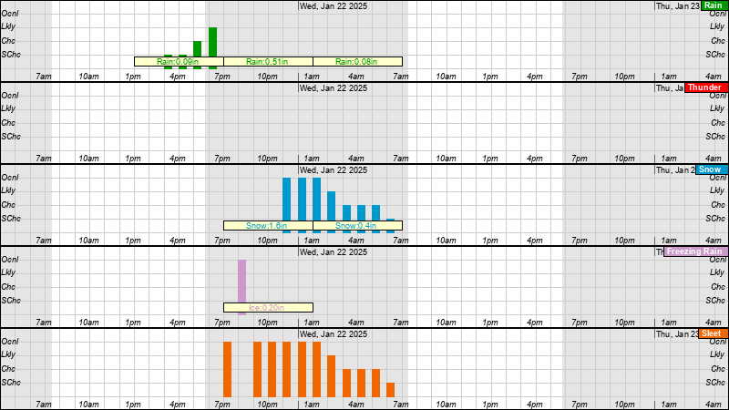
It should start out as rain, then change over to sleet then snow. The problem is that south of Savannah is likely to be more freezing rain in the mix. We worry about freezing rain because much more than about 0.25″ can cause a lot of problems, not just on the roads and sidewalks, but it sticks to trees and power lines and can cause outages, limbs coming down, etc. If Savannah gets more freezing rain it will be Bad. At this point we just don’t know what the mix will be, the forecasts shift from run to run. Bottom line, stay off the streets after sunset. North of the river, closer to Frogmore proper (Beaufort), it looks to go from rain to sleet to snow with less chance for freezing rain. Here is what WSFO/Charleston has to say at 5:30am:
At this time, it is believed that total snow accumulations of 1.5 to
2.5 inches are possible, with areas from Reidsville and Statesboro,
GA to Summerville and Jamestown, SC being placed in the most
favorable zone of snowfall potential for a longer period of time.
Further south, freezing rain with ice accumulations around 0.25
inches are possible along the Georgia coast. However, there is
greater uncertainty in freezing rain accumulations, including the
potential for slightly higher amounts along I-95 south of Chatham
County, GA. Should colder temps arrive across this area earlier,
snowfall amounts could approach the 1.5 to 2 inch range here as
well, with some latest model guidance suggesting this possibility.
Either way, most folks in the region should wake up to 1-2″ of sleet and snow on the ground. Further inland may see 2-3″. The band of heavier snow also keeps shifting from run to run. Here is an animation from the NAM-HIRES run this morning …

The snow should stick around through Thursday. Beware that any melt Wednesday and the greater melting Thursday will refreeze overnight, so the Invisible Touch of black ice and hazardous travel conditions will persist. Friday things may be able to return to normal, as temps should start to warm up a little, but we will have to wait and see if an expected pulse of moisture Thursday drops some more frozen stuff (it looks weak right now).
For those in North Florida and Georgia south of Darien, check the Jacksonville NWS office site for updates. For the Greater Frogmore Metroplex (coastal GA/SC), the Charleston office has you covered. Those unfortunates further inland can check the Peachtree City or Columbia offices if in GA or SC respectively.
Those of you who are under 55 or so and not classical music (or Miami Vice) fans might not get the references so here’s some help …
and a great song/show that captures the spirit of the 80’s …
If you like this kind of commentary you can subscribe to the emails (and/or donate to keep it going) at this link. You can also follow us on X/Twitter (@EnkiResearch) or even Facebook if that’s your preferred social media dystopia, although the blog is the primary forum.
Thank you for this update! You are appreciated very much!
Thank you and I love the music!
Good one today! Love the music references. Made me smile. And the songs are stuck in my head. Thank you for your perspective. Stay safe and warm.
Loved all your music references today!
Thank you for a very informative forecast!
Thanks, Chuck.
Thank you, as always. Love, love Phil Collins and always watched Miami Vice.