

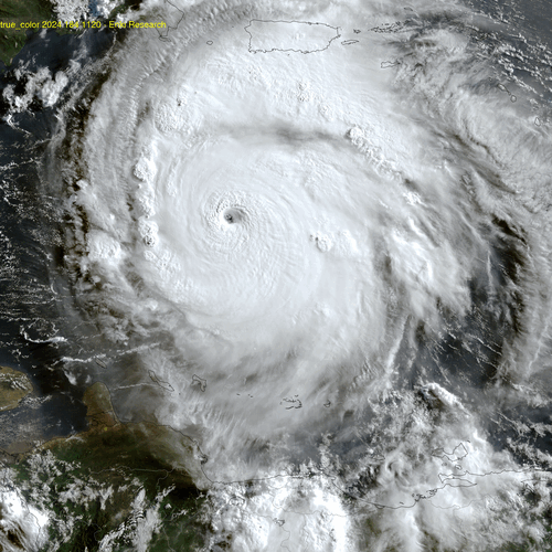
Beryl is bearing down on Jamaica. The latest objective model runs show it tracking right over the island, and even if it decays some in strength this will be a major disaster. As of the 11am NHC advisory – Key Messages regarding Hurricane Beryl (en Español: Mensajes Claves) – the official forecast track shifted a bit more north and as of now the eye is expected to pass over or just south of the island in about 30 hours still as a major hurricane. Here is the impact swath based on the 11am forecast:

On the “plus” side, Beryl probably hit peak intensity around 8am and is starting to encounter some shear (environmental winds pushing the storm in different directions at different altitudes). Look carefully at these two animations, and watch how the western (left) edge of the storm warms (less deep dark red colors) and gets “fuzzier” and less symmetrical … (click either to embiggen):

Hopefully the weakening trend will accelerate. The computer track models remain pretty consistent – but as noted in this morning’s post even minor, 20km wobbles will mean life and death for many in Jamaica. Here are the latest runs, as well as the 5am forecast (red) and position fixes from satellite and aircraft:

This is some of the raw data the forecasters at the National Hurricane Center have to make sense of. As you can see, and this is a very consistent, easy to track storm, yet interpreting the model tracks (which are now several hours old) and the latest position fixes is complicated. Where do you update that line – keeping in mind millions of people depend on you to get it right? This is why I say while it’s interesting to look at the details, any web site that spends too much time talking about this or that model is probably not one you want to trust – expanding and explaining the NHC forecast (as I try to do) is one thing, doing your own forecast is pretty risky in most cases.
If you find this kind of commentary valuable you can sign up for direct emails in the box below. Contributions appreciated but not required.