

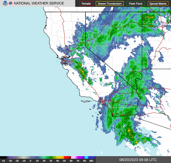
Lots going on this morning (6am Sun. 20 Aug), starting with Hilary. As expected the rapid weakening continues, the storm now barely a hurricane. However, heavy rains are already moving across California and the desert Southwest this morning as this radar composite shows:
At this point the forecast track and winds are secondary, but for the record here is the TAOS/TC impact estimate based on the latest (5am) forecast from the National Hurricane Center:

As always your best source of information on warnings and precautions are the official sites, here are links to NHC’s Key Messages regarding Hurricane Hilary (en Español: Mensajes Claves). The bottom line is that the remnants of Hilary are going to dump a lot of rain on the southwest. Here is the excess rainfall/flash flood potential estimate from WPC – if you’re in the area in purple or, um, tomato red?, definitely take precautions, especially if you are in an area where there is flooding potential. Don’t drive around if you don’t have to – roads turn in to rivers out there.

I get irritated sometimes that when these kinds of events happen there will be replies (usually on Twitter/X) to the effect of “California will benefit as it needs the water & it’s only expected to be a tropical storm.” This is of course dumb, to be polite. Yes, wind impact will be minimal. The problem is the rain rate – a slow, soaking rain might be ok, but the high rates in a tropical cyclone can be catastrophic in a desert landscape. Most of it quickly runs off (the rain rate is much greater than the infiltration or storage rates), so the potential for destructive flash flooding, erosion, and slope destabilization (mudslides) is high. That’s Hydrology 101 – rain amounts and rates that won’t get a bored shrug in Georgia are literally a disaster in southern California or Arizona.
Economic impacts from wind will likely be minimal (unless, of course, it’s your roof that fails). In Mexico likely under $200 million, in the US probably under $100 million. But flood damage may push this into a Billion dollar storm in the US.
The Atlantic is active, but no serious threats at the moment. Tropical Depression Six formed last night – and is already breaking up. It’s only impact will be to inflate the number of storms for the year. No warnings or “Key Messages” from NHC.
Invest area AL90 has passed over St. Vincent and the Grenadines, and is expected to continue westward before taking a sharp northward turn. The current forecast gives it a 70% chance of developing into a tropical depression in the next few days, the GFS model (shown here) then takes it over the Dominican Republic as a middle grade tropical storm:

Assuming you are not a fish or in the shipping or sailing business (there are two systems in the far east Atlantic they might care about), there is a disturbance over the Florida Keys that is expected to move into the Gulf of Mexico today. It does not have an invest area number yet, but is given a 50% chance of becoming at least a tropical depression before impacting Texas or the north Gulf coast of Mexico later this week. Should have more on this potential tomorrow.
As a reminder, social media is a terrible way to get news. The algorithms have become increasingly aggressive in limiting the reach of posts that take you to outside sources of information (they want to keep you on their platform), and they rate posts by activity, not currency, so an old post that lots of people have seen will be promoted over more recent information. So beware! In this case, you can get these posts directly in your email by signing up below. While contributions are optional, they are appreciated and help pay for the hardware that runs the models as well as the WordPress site to keep things going.
Thank you for sensible and fact based information.
How is the dollar damage estimate derived?
As you might imagine it’s a fairly complex process. Short version is the physical phenomena is modeled (hurricane, earthquake, etc) and the forces impacting each 463 meter square area of the surface of the earth are calculated. This information (wind speed, water depth, wave height, water velocity/flow, or ground motion) is then used to calculate the impact of those forces on the human infrastructure(buildings, etc). The infrastructure data base is derived from satellite data as well as economic data to estimate the value of that infrastructure as well as the economic activity from that infrastructure and the people who live there. Started working on a post describe the process in more detail but keep getting side tracked.
Thank you. I always look to your analysis (and the NHC messages) for solid, good information.