

TL;DR: In southeast, prep for below freezing temps tonight/tomorrow, right up to the coastlines. The northeast is getting a classic nor’easter with lots of wind and snow right on the coastline impacting the NJ/NY airports so national traffic will suffer.
Not a lot to add to yesterday’s post. The cold front spawning a nor’easter is moving off the coast this morning. One more band of showers looks to cross coastal GA and the SC Lowcountry this morning …

So far in Savannah we’ve only had 0.61″ of rain as of 6 am. We seem to be in a “dry” band in between two areas that got a bit more, according to the latest radar accumulations just before 6am …

That will help, but the area is still well below normal rainfall and a drought is in progress.
As noted yesterday, temps will drop rapidly today. Tonight will be below freezing inland of I-95 for sure, and likely right at freezing on the coast, so it’s a “protect the plants” night. Wind chills might hit the teens in the morning. Tomorrow will be windy and (by southern standards) cold, so keep anything you want protected wrapped up, Monday night will be colder with 20’s all the way to the coastline in the Frogmore Metroplex (Coastal GA/Lowcountry of SC)

The real news about this system is to the north, where a low pressure system is forming that will race up the coast and dump high winds and perhaps as much as a foot of snow on the New Jersey/New York and Massachusetts coastlines. The entire area north of the DelMarVa Peninsula is in for some significant weather. Here is the latest (as of 5:22am) from WPC:
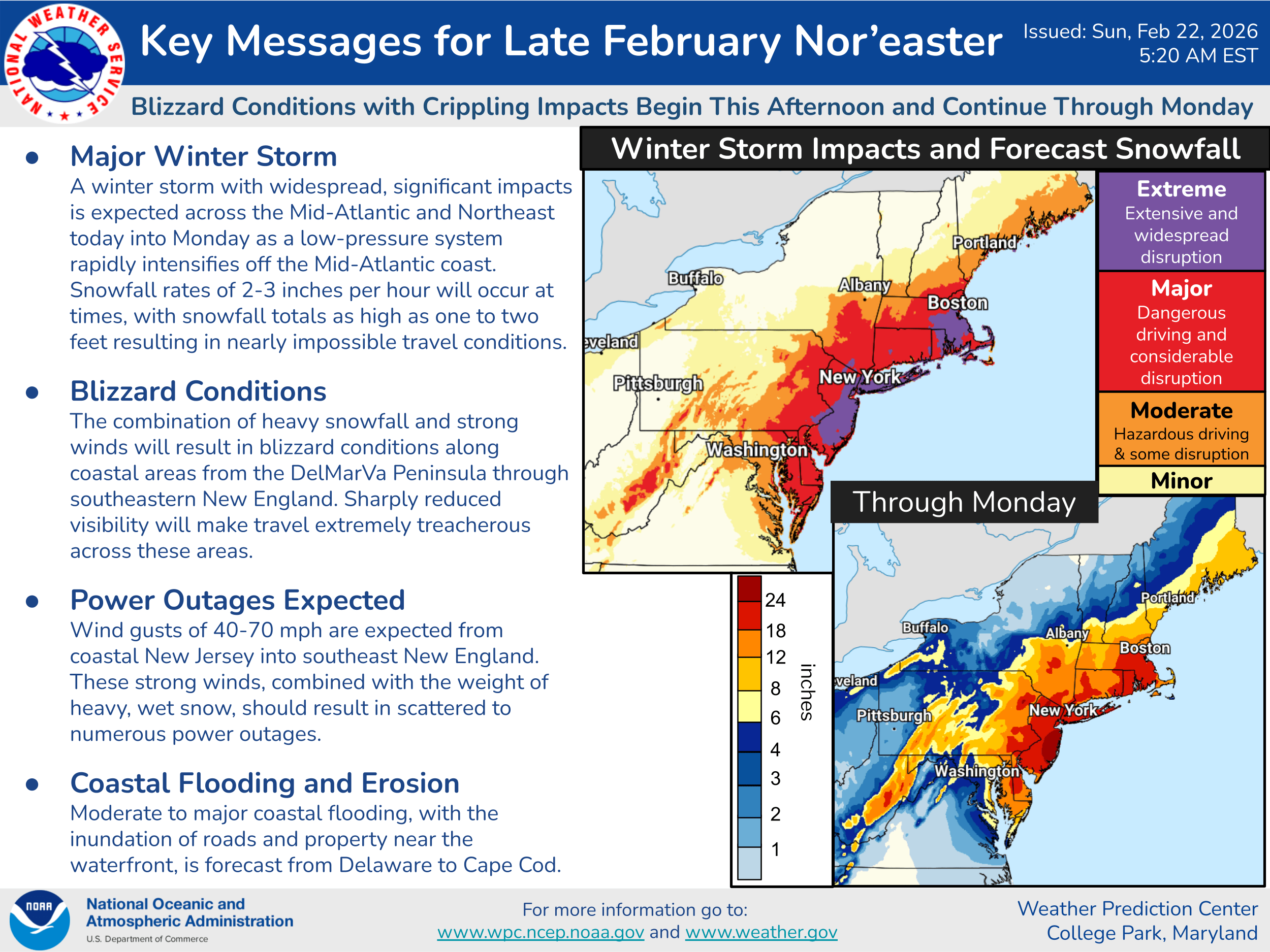
Notice the major airports of JFK, LGA, and Newark are in the purple “extreme” disruption zone, as well as Boston/Logan. There are no delays yet on the FAA’s status board, but by this evening traffic will almost certainly be impacted so if flying this afternoon or tomorrow expect delays. Bug your airline about that.
If you appreciate the blog, the best way to get it is to subscribe to the emails. You can subscribe and also donate to keep it going at this link.
You can also follow us on X/Twitter (@EnkiResearch), Telegram, BlueSky, or even Facebook if that is your preferred social media cesspool.